All Posts
GeoFly Lab Members Contribute to 'Histories of Fire and Industry in the Santa Cruz Mountains'
2 minutes read
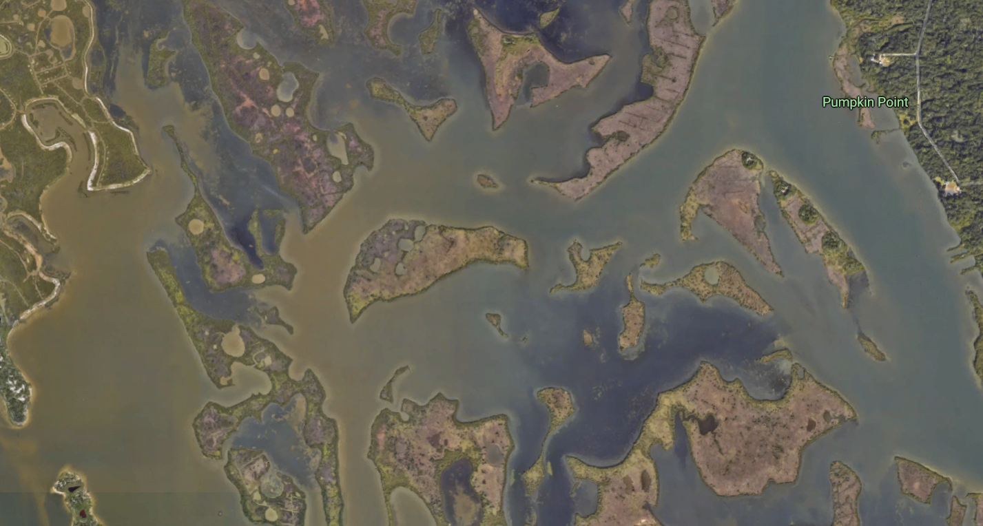
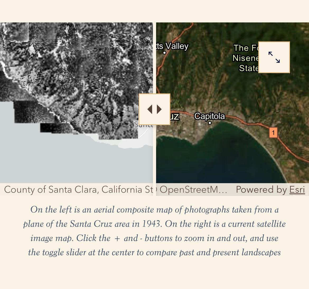
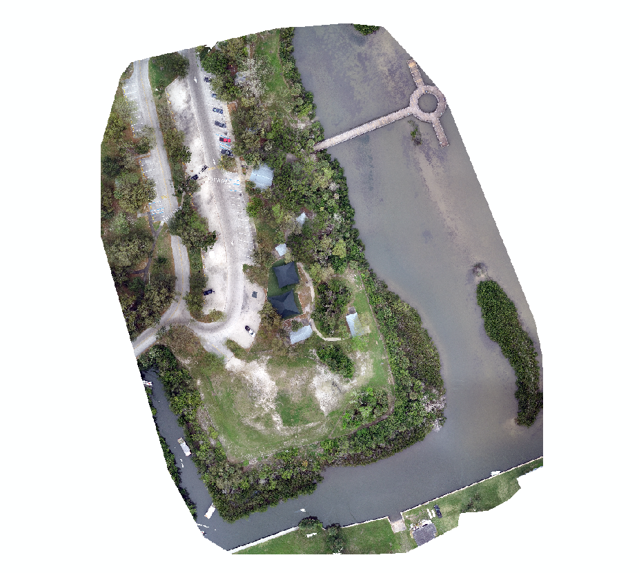
GeoFly Lab members Griffin Svec-Burdick and Nathan Leroy contributed georeferenced aerial photographs to the project "Histories of Fire and Industry in the Santa Cruz Mountains," collaborating with Professor Andrew Mathews .…
January 20, 2026
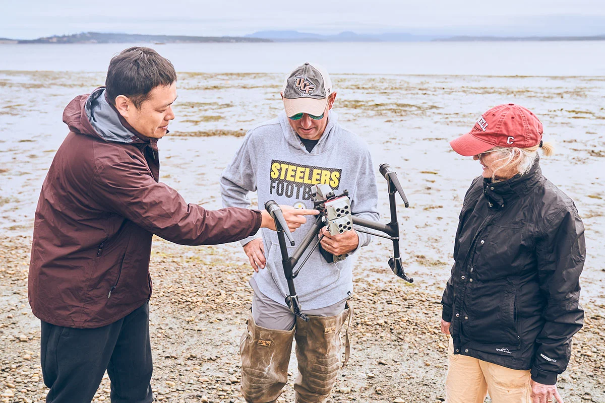
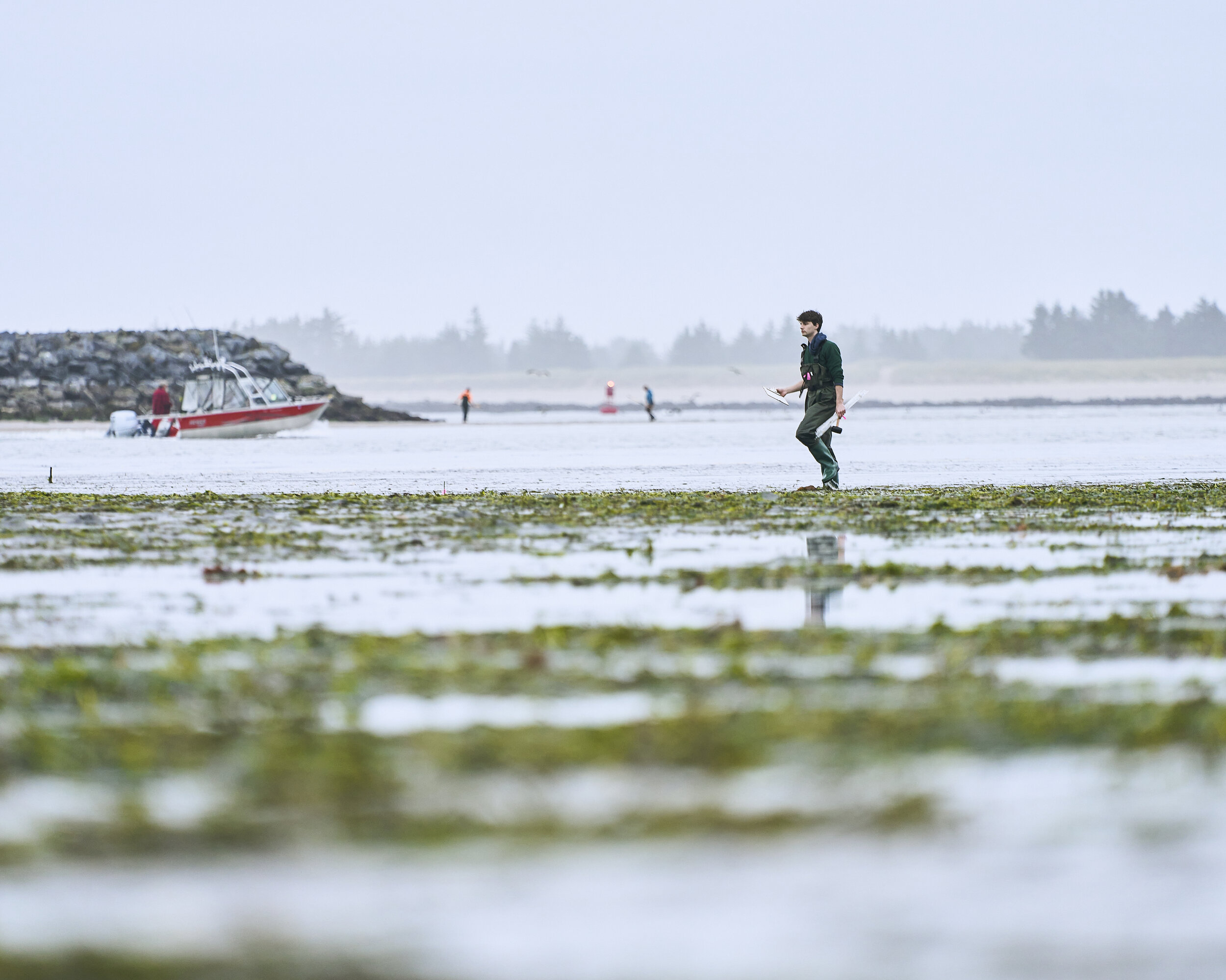
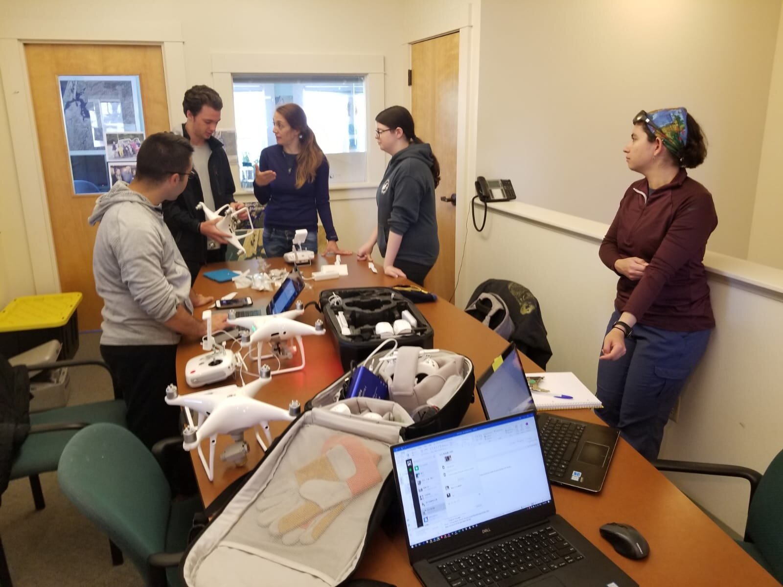
GeoFly Lab welcomes a new eBee X drone for our NSF seagrass mapping project
1 minute read
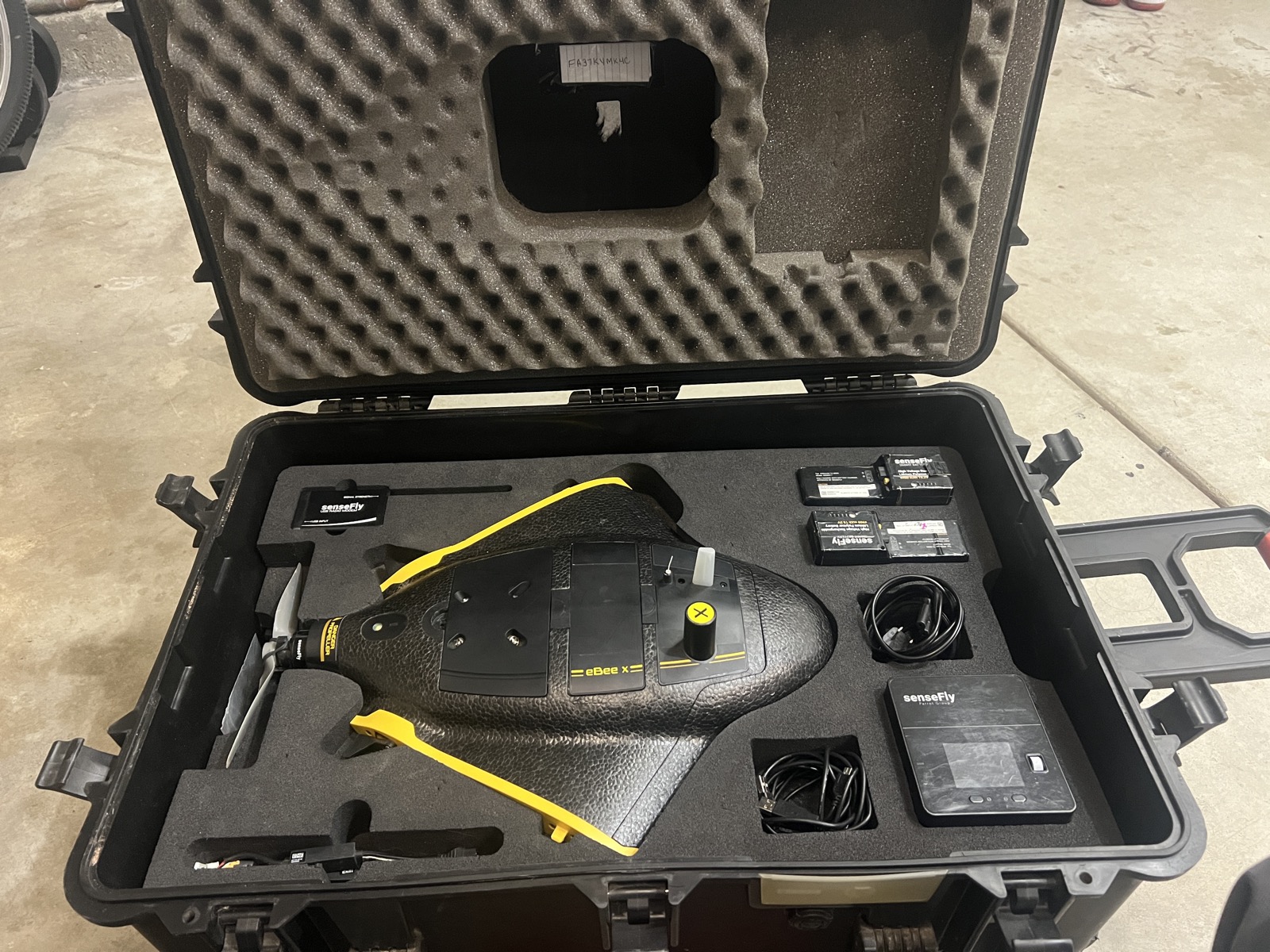
GeoFly Lab has added a new senseFly eBee X fixed-wing drone to support our NSF-funded seagrass mapping work.…
January 15, 2026
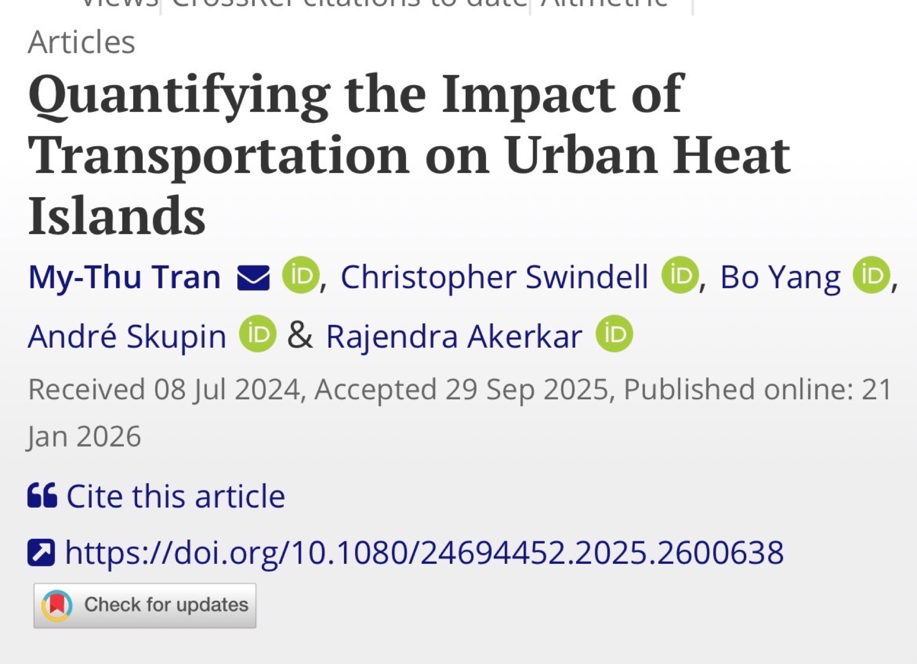
New paper in Annals of AAG: thermal remote sensing of traffic impacts on urban heat during COVID-19
1 minute read
GeoFly Lab published a new paper in Annals of the American Association of Geographers that uses thermal remote sensing to assess how traffic activity influences urban heat island intensity during the COVID-19 lockdown period.…
January 15, 2026
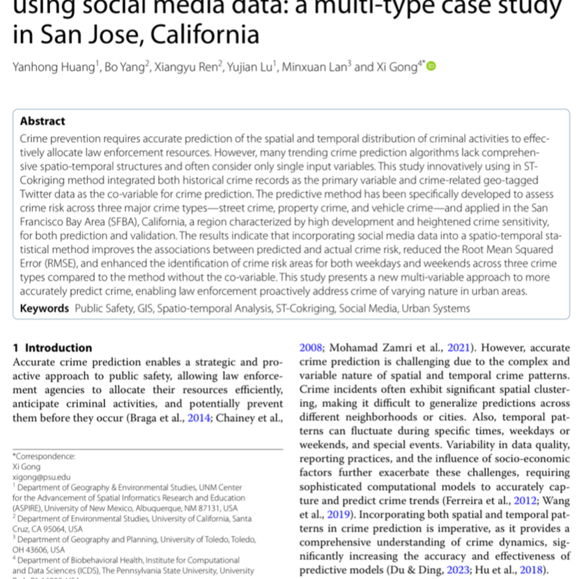
New paper: crime prediction using Twitter data in San Jose
2 minutes read
GeoFly Lab published a new study on crime risk prediction that combines two information sources: (1) historical crime records and (2) crime-related geo-tagged Twitter signals . The work focuses on improving when and where elevated risk is likely to occur, to support more informed resource planning.…
December 30, 2025
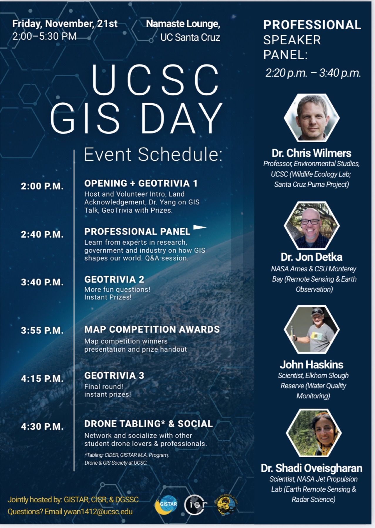
UCSC GIS Day 2025: Jointly hosted by GISTAR, CISR, GeoFly Lab, and the GIS & Drone Society
1 minute read
GISTAR, CISR, GeoFly Lab, and the GIS & Drone Society jointly hosted UCSC GIS Day 2025 at the Namaste Lounge, UC Santa Cruz. The event brought together a full room of students to learn, connect, and celebrate geospatial science.…
November 21, 2025
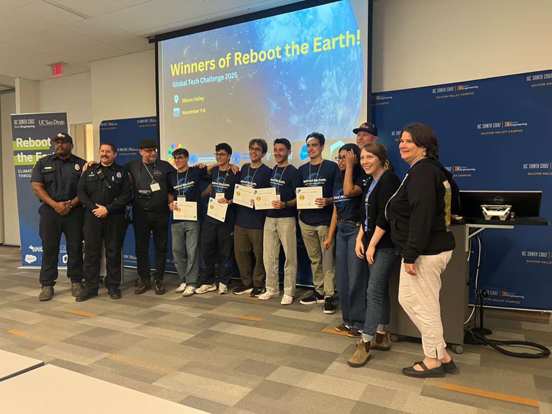
GeoFly Lab serves on judging panel for Reboot the Earth UN Innovation Competition
1 minute read
GeoFly Lab was honored to serve on the judging panel for the Reboot the Earth UN Innovation Competition hosted at the UCSC Silicon Valley Center . The event brought together student innovation teams from UC Santa Cruz , UC San Diego , and other UC campuses to propose actionable solutions for wildfire -related challenges.…
November 08, 2025
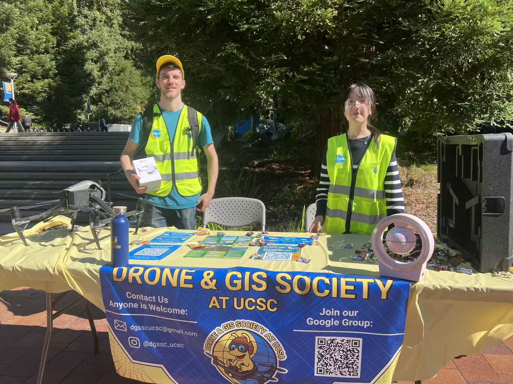
Drone & GIS Society Featured at Baskin Day
2 minutes read
On Thursday, October 17, the Drone & GIS Society represented UCSC’s growing geospatial community at Baskin Day 2025 in the Baskin Courtyard. Students and visitors learned about current projects, upcoming events, and opportunities to get involved in drone and GIS activities on campus.…
October 17, 2025
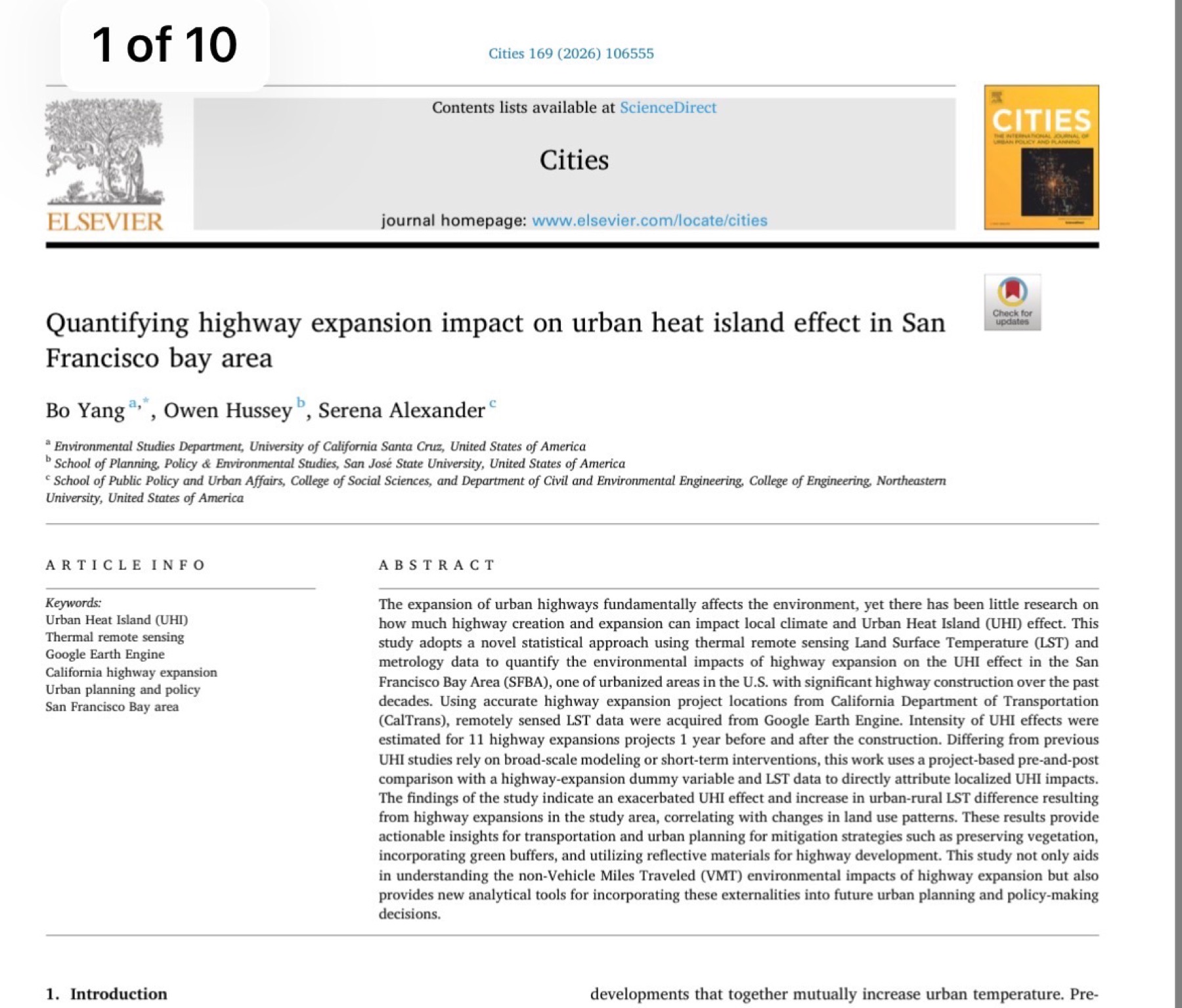
New paper: highway expansion impacts on urban heat using Google Earth Engine
2 minutes read
GeoFly Lab published a new paper that quantifies how highway capacity expansion relates to urban heat island patterns in the San Francisco Bay Area. This work was supported by a Mineta Transportation Institute (MTI) grant.…
October 01, 2025
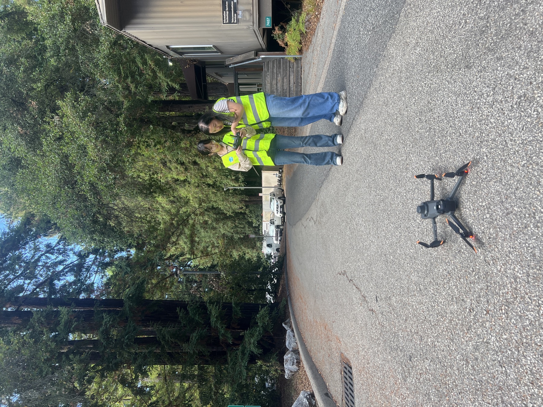
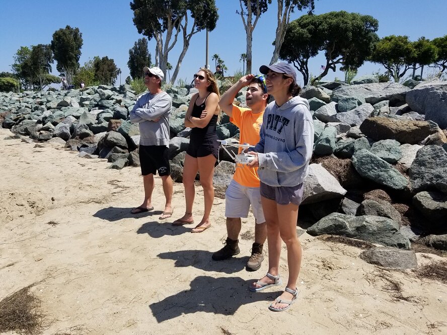
GeoFly Lab kicks off the academic year with basketball and drone flights
1 minute read
To mark the start of the new academic year, GeoFly Lab gathered for an informal activity session that combined two priorities of our lab culture: team building and hands-on field practice .…
September 19, 2025
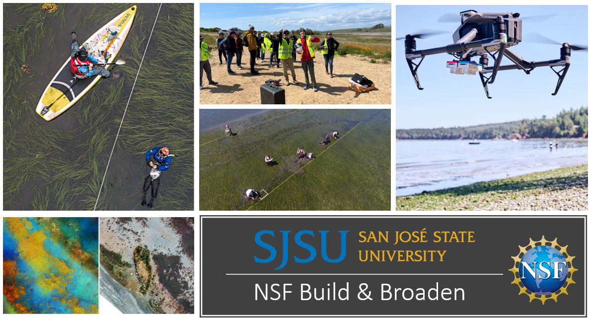
NSF Build and Broaden 2024 Summer Coastal Drone Fieldwork Application
2 minutes read
The NSF Build and Broaden 2024 summer fieldwork application is now open! This unique program invites students to participate in a four-week coastal mapping fieldwork adventure spanning Bodega Bay, Tomales Bay, Oregon, and Moss Landing. This initiative, supported by the National Science Foundation (NSF), offers an invaluable opportunity for selected students to engage directly with the environment and cutting-edge research. Learn more about the multi-year seagrass mapping project [here]…
February 20, 2024
Geofly Lab has two funded Master's Research Assistant (RA) positions available.
1 minute read
Geofly Lab has two funded Master's Research Assistant (RA) positions available. Please check the pdf for more info below.…
February 01, 2024
NSF Funds Innovations: Wildfire Research Projects Secure Industry Advisory Support
1 minute read
Exciting news! We are thrilled to announce that both of our Industry Advisory Board proposals to the Wildfire Interdisciplinary Research Center have successfully secured funding from the National Science Foundation (NSF) IUCRC. The projects, "Post-Wildfire Fuels Management using a Multi-source Remote Sensing Approach" and "Enhancing Community Fire Resilience Decision-Making: Drone Inspection for Home Ignition Zone," stood out in a highly competitive pool of proposals. This significant achievement marks a major milestone for our group. Congratulations to everyone involved for their hard work and dedication! This success paves the way for further innovative research in wildfire management and community safety. 🎉…
January 19, 2024
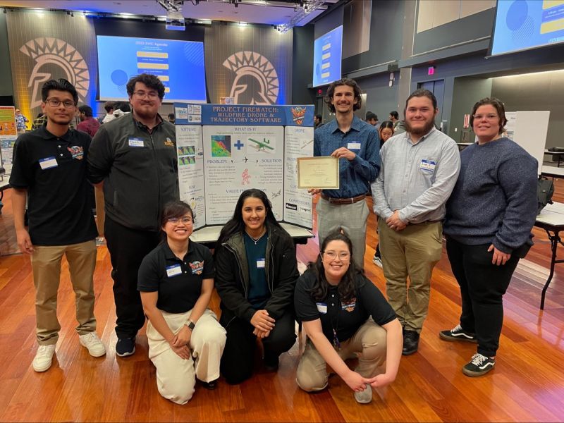
Team FireWatch won 2nd Place in Silicon Valley Innovation Competition
1 minute read
The FireWatch Team from SJSU, blending expertise in Software and Aerospace Engineering, clinched 2nd place among 147 teams at the Silicon Valley Innovation Competition. Their innovative project combined GIS, engineering, computer vision, and drone tech for advanced California wildfire modeling, earning widespread praise. With support from SJSU's College of Engineering, the Wildfire Interdisciplinary Research Center, the Department of Urban and Regional Planning, and the GIS & Drone Society, their success highlighted the power of cross-disciplinary collaboration. Team members Sofia Silva, Jose Betancourt Jr. Huizar, and Nha Alvarado, advised by Dr. Bo Yang, showcased their project's potential for significant real-world impact.…
November 29, 2023
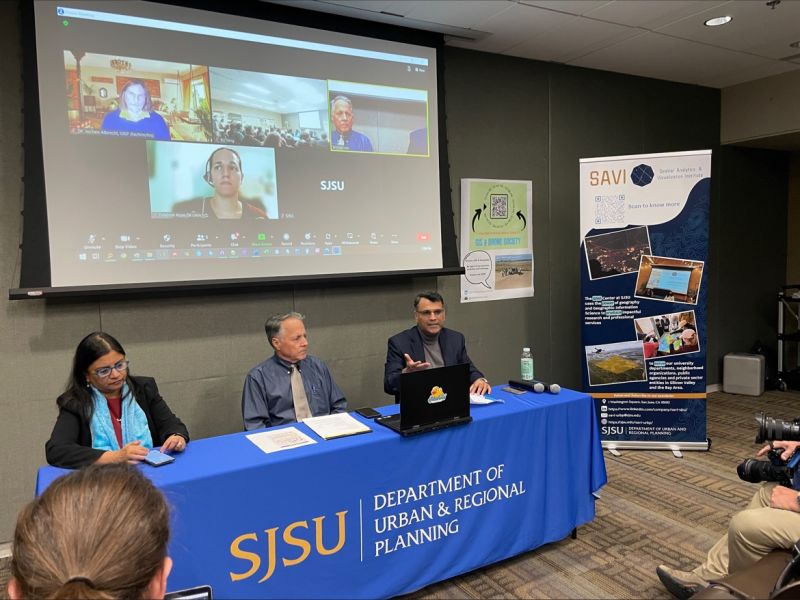
Celebrating Innovation and Collaboration at SJSU GIS Day
2 minutes read
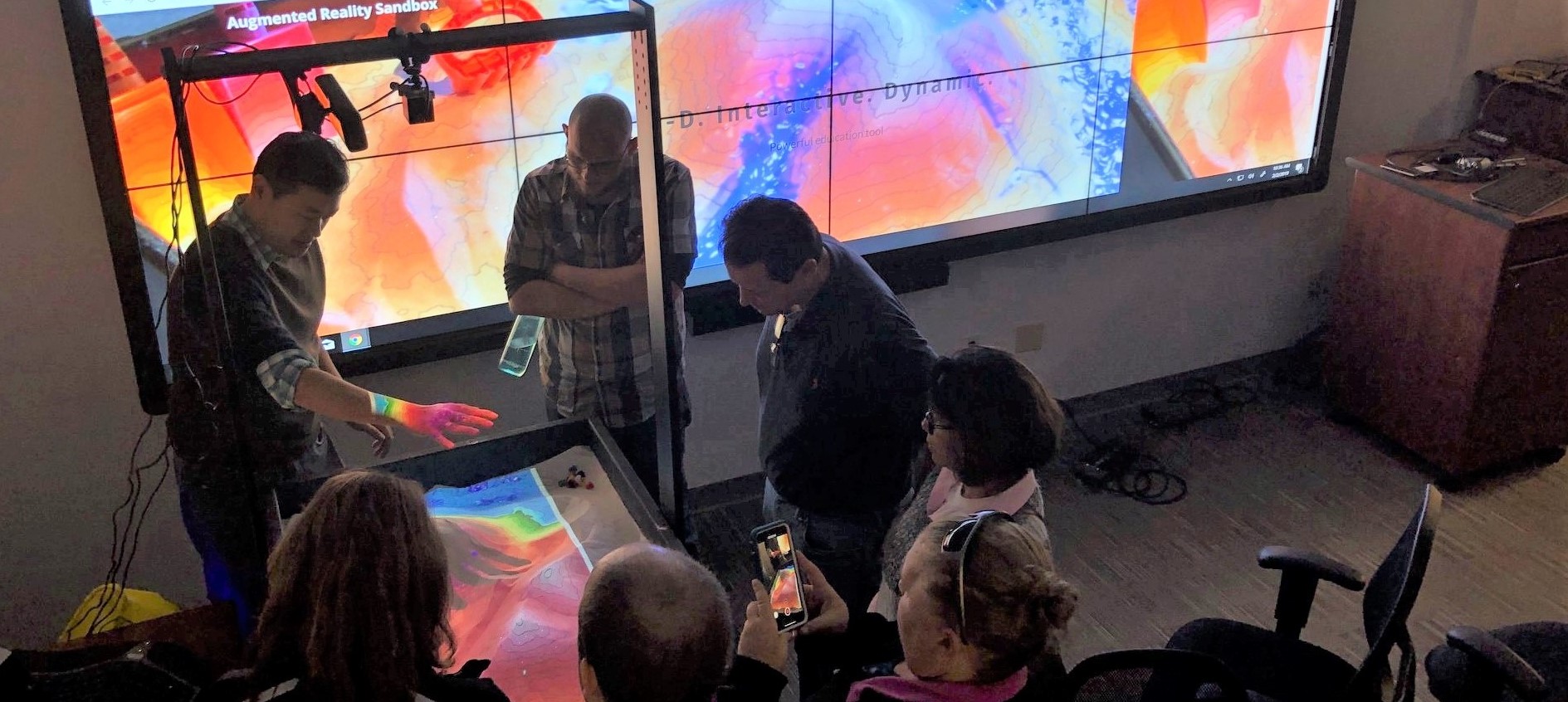
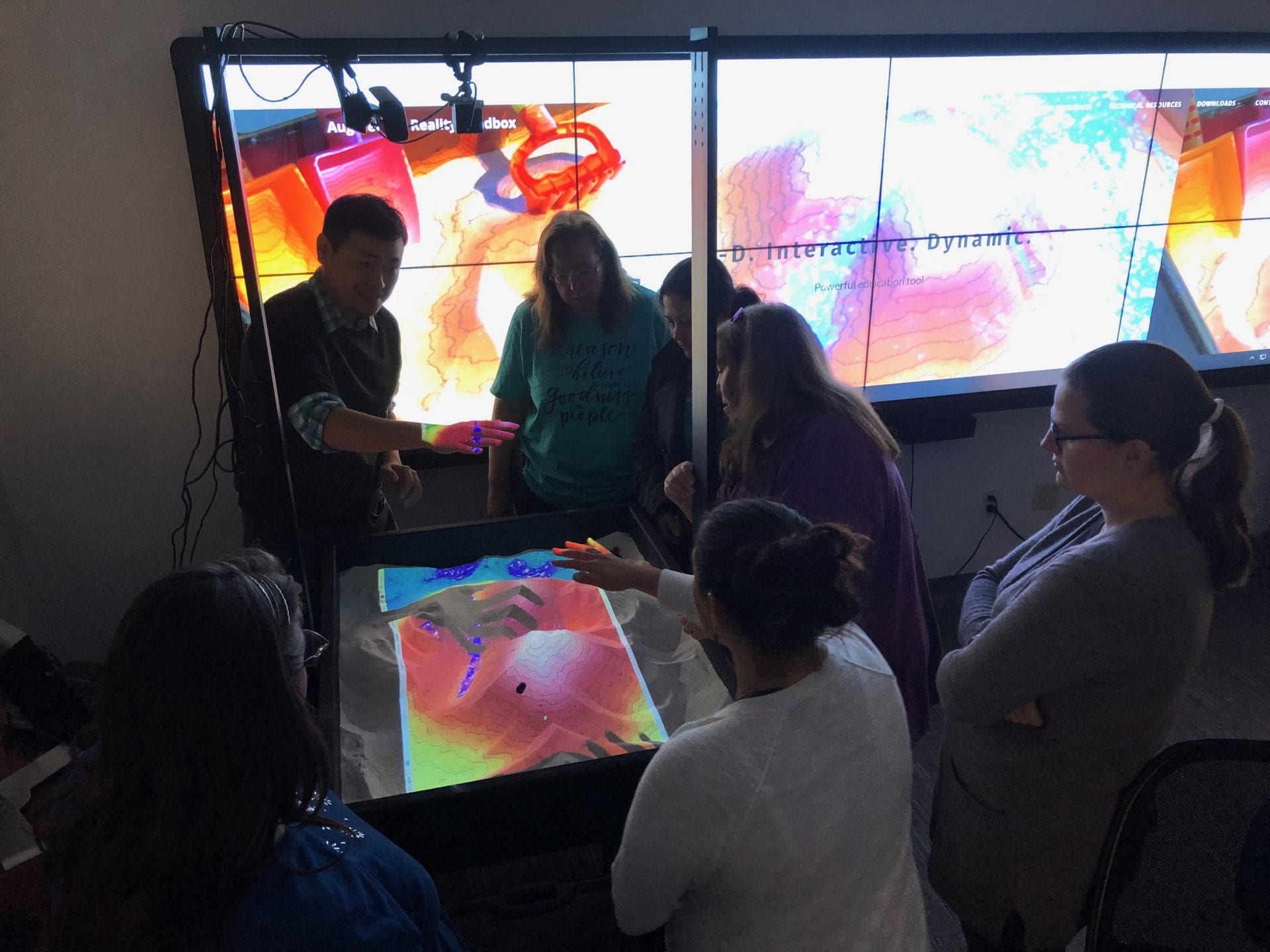
The SJSU SAVi Center and the GIS & Drone Society are thrilled to express our heartfelt thanks to all the participants and attendees for making GIS Day an outstanding success! Hosted by Dr. Bo Yang, this year's event was particularly special as we introduced the first-ever GIS Day housing panel, featuring esteemed faculty members Dr. Laxmi Ramasubramanian, Dr. Shishir Mathur, Dr. Jochen Albrecht, Deborah Rojas, and Jeffrey Hare, who shared their insights on housing and GIS. The GeoFly Lab team presented impressive drone demonstrations, and attendees were also treated to SJSU's first augmented reality sandbox, created by Owen Hussey and…
November 16, 2023
![[Post] Exploring Ecological Impact SJSU GIS & Drone Society's Collaborative Efforts](./posts/images/2023111001.jpg)
[Post] Exploring Ecological Impact SJSU GIS & Drone Society's Collaborative Efforts
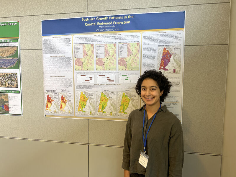
1 minute read
The SJSU GIS & Drone Society successfully concluded a comprehensive data collection session at Wilder Ranch State Park. Led by Jannike Allen and David Benterou from the Fire Ecology & Management Lab, along with UC Santa Cruz collaborators, temperature data was gathered. Geography student Xiangyu REN contributed by capturing post-fire drone imagery, aiding in burn severity assessment and fuel volume estimates. This interdisciplinary effort showcased the significance of prescribed fire, emphasizing its ecological benefits. The team's dedication highlights the potential for further insights, underscoring the society's commitment to interdisciplinary research merging biology and geography. Hashtags #prescribedfire #beneficialfire #biology #geography encapsulate…
November 10, 2023
![[Post] Collaborative Burn Day SJSU's GIS & Drone Society's Ecological Impact](./posts/images/2023110901.jpg)
[Post] Collaborative Burn Day SJSU's GIS & Drone Society's Ecological Impact
1 minute read
The SJSU GIS & Drone Society had an impactful day at Wilder Ranch State Park collaborating with California State Parks' fire team. Professor Kate Wilkin's biology team gathered crucial fuel moisture and burn data, complemented by geography student Henri Brillon's post-burn aerial imagery for precise fuel volume estimates. This interdisciplinary effort showcased the benefits of prescribed fire. Gratitude was extended to everyone involved in this endeavor, emphasizing the significance of interdisciplinary research in merging biology and geography. The event exemplified the society's commitment to leveraging technology for understanding and enhancing the ecological significance of controlled burns. Hashtags #prescribedfire #beneficialfire #biology…
November 09, 2023
![[Post] Highlighting SJSU GIS & Drone Society's Impact at VTA's GIS Day](./posts/images/2023110601.jpg)
[Post] Highlighting SJSU GIS & Drone Society's Impact at VTA's GIS Day
1 minute read
SJSU GIS & Drone Society had an insightful experience at VTA's engaging GIS Day, where Xiangyu REN and Henri Brillon showcased their posters and interacted with VTA personnel. Professor Bo Yang highlighted the society's drone, LiDAR, and remote sensing projects. Gratitude was extended to Chao Liu and Taha Rao for their hospitable hosting. The event emphasized GIS, geography, and transportation, fostering collaboration between SJSU's Department of Urban and Regional Planning and VTA. This occasion provided valuable networking opportunities and a platform to share ongoing initiatives, showcasing the society's commitment to technological innovation in spatial analysis and its applications in various…
November 06, 2023
![[Post] SJSU Graduate Fair Uniting Passion for GIS and Urban Planning](./posts/images/2023110301.jpg)
[Post] SJSU Graduate Fair Uniting Passion for GIS and Urban Planning
1 minute read
At the #SJSU Graduate Fair, the SJSU GIS & Drone Society connected with passionate GIS and Urban Planning enthusiasts, igniting inspiration. Engaging with many, we're excited to further conversations and shape the future collaboratively. Join us! #GIS #UrbanPlanning #Networking #GraduateFair #Drone4SJSU 🎓✨…
November 03, 2023
Bo Yang's Drone Innovations Transforming GIS Research Across Environments
1 minute read
Bo Yang's pioneering use of drone technology revolutionizes GIS research. As an assistant professor at San José State University's Department of Urban and Regional Planning, he employs drones to explore coastal ecosystems and wildfires. Securing a National Science Foundation grant, Yang and co-investigators plan to engage students from various institutions in drone-assisted studies. Using diverse sensors and cutting-edge technology, they monitor seagrass changes due to environmental factors. Yang's interdisciplinary student teams face challenges, from seagull attacks to coastal winds, but their commitment to extracting valuable data remains unshaken. Moreover, his collaboration with the Wildfire Interdisciplinary Research Center delves into fire…
October 01, 2023
![[Post] Dr. Karen Joyce Pioneering Circular Drone Data Economy Collaboration Vision](./posts/images/2023092201.jpg)
[Post] Dr. Karen Joyce Pioneering Circular Drone Data Economy Collaboration Vision
1 minute read
…
September 22, 2023
[Post] Advancing Drone Tech SJSU's Remote Sensing Presentation Success Recap
1 minute read
Professor Bo Yang showcased our ongoing drone and remote sensing projects in a comprehensive presentation to the Department of Meteorology and Climate Science at SJSU. View the full presentation below!…
September 15, 2023
Post: GeoFly Lab awarded NSF B2
2 minutes read
GeoFly Lab at San Jose State University has achieved a remarkable milestone, receiving the prestigious NSF B2 program award for a groundbreaking project in collaboration with UC Davis. This initiative focuses on utilizing Unmanned Aerial Vehicles (UAVs) and Geographic Information Systems (GIS) for the advanced mapping of seagrass ecosystems. The project, supported by the National Science Foundation (NSF), showcases the innovative integration of technology in environmental research.…
August 16, 2023
[Report] Advancing Wildfire Research: Prof Bo Yang Present Drone Innovations at SJSU MetCS Seminar
2 minutes read
In a pioneering study published by the Mineta Transportation Institute, researchers My-Thu Tran and Dr. Bo Yang have utilized thermal remote sensing to investigate the impact of traffic on urban heat islands during the COVID-19 pandemic. This research is groundbreaking in its approach, using advanced remote sensing techniques to explore the interconnection between transportation and urban climate change.…
May 01, 2023
Advancing Wildfire Research: Prof Bo Yang Present Drone Innovations at SJSU MetCS Seminar
1 minute read
The San Jose State University (SJSU) Drone class, known as GEOG282/173, recently embarked on an enriching field trip to Moss Landing Marine Lab, offering students a hands-on experience in the dynamic environment of Elkhorn Slough. This outing was more than just a practical exercise; it was an immersive journey into the world of research fieldwork, highlighting the practical applications of drone technology in environmental studies.…
April 19, 2023
![[Post] San Jose State's Urban Planning Research Excellence at AAG 2023](./posts/images/2023032401.jpg)
[Post] San Jose State's Urban Planning Research Excellence at AAG 2023
2 minutes read
Dr. Bo Yang, an Assistant Professor at San Jose State University, proudly showcases the exceptional representation of the university's COSS Department of Urban and Regional Planning at the AAG 2023 event in Denver. The diverse research exhibited by students and former alumni reflects the department's strong commitment to various domains.…
March 24, 2023
UAV Applications in Wildfire Research Mapping, Analysis, and Future Trends
2 minutes read
CalGIS 2023, hosted by California URISA and the California Geographic Information Association, invites professionals to Monterey County for a comprehensive conference focused on GIS solutions, education, and networking opportunities. The event offers various registration options for different membership levels, including students, young professionals, and industry experts. Limited sponsorship and exhibit opportunities are available.…
March 15, 2023
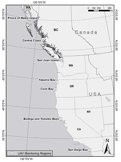
[Paper] UAV Imaging Tracks Eelgrass Disease Across Pacific Coastal Ecosystems
2 minutes read
The study introduces an innovative approach utilizing Low-Altitude Unmanned Aerial Vehicle (UAV) imaging to track and forecast wasting disease affecting eelgrass, a crucial coastal ecosystem. Researchers conducted UAV surveys and sampling in intertidal eelgrass beds spanning various locations from Alaska to California. Their developed low-altitude UAV mapping technique aimed to identify disease prevalence, cross-validated against in situ findings.…
February 28, 2023
[Paper] Quantifying Seagrass Decline UAV Imaging Unveils Climate Stress Impact
2 minutes read
The article delves into the decline of San Juan Island's seagrass meadows and how high-resolution UAV imagery, alongside in situ sampling, quantifies the impact of disease and thermal stress on these ecosystems. Over a decade, San Juan's seagrass shoot densities fell by 90%, with persistent wasting disease infections exceeding 40% since the 2016 heatwave. Synchronized UAV surveys and in situ sampling have enhanced data comprehensiveness, revealing extensive seagrass loss beyond monitoring transects, emphasizing the urgency for landscape-scale monitoring.…
January 23, 2023
2022 SJSU GIS Day celebration featuring keynote speakers and a student poster competition
1 minute read
Video…
November 16, 2022
[StoryMap] Breakthrough Research Understanding California's Canyon Wildfires Using Advanced Technology
2 minutes read
The Wildfire Interdisciplinary Research Center (WIRC) at San Jose State University, alongside various partners and researchers, conducted groundbreaking research on California wildfires in a canyon near Salinas. This vast experiment aimed to comprehend wildfire behavior in challenging canyon terrain, crucial due to its historically understudied nature and high risk for firefighters. Employing cutting-edge technology including drones and mobile Doppler radar, researchers captured invaluable data on the fire's behavior, plume dynamics, and intensity. The controlled burn, the largest of its kind in a canyon, facilitated the collection of detailed information instrumental in refining mathematical models for predicting fire behavior in complex…
October 25, 2022
The SJSU GIS and Drone Society has been invited to bring members to the Drone Racing League’s opening season at PayPal Park
1 minute read
Share:…
October 11, 2022
SAVI Fall 2022 Hands-On Spatial Analytics Workshops for Professionals, Students
1 minute read
The Spatial Analytics and Visualization Institute (SAVI) announces its Fall 2022 workshop series, offering professionals and students innovative hands-on skill development in spatial analytics. In November, SAVI presents 3-hour lab sessions led by expert instructors from private industry and higher education. Individual workshop fees range from $275 (early bird) to $300 (regular) while the full program fee varies from $975 to $1000. SJSU students can access these workshops for free, thanks to support from Public Interest Technology University Network and Mary Brugo endowment.…
October 05, 2022
UAV Training Program for Seagrass Monitoring Top-Viewed Drone Research
1 minute read
Check out the top-viewed paper on @Drones_MDPI! It introduces a UAV/drone mapping training program for seagrass monitoring and research. Authored by @BoYangGeo, @timlhawthorne, @HessingLewis, and others. Dive into the full paper here: https://mdpi.com/2504-446X/4/4/70 #drones #UAV #Seagrass…
September 28, 2022
San Jose State's Summer Drone Class Sparks Teen Engineering Enthusiasm
1 minute read
San Jose State University's Mineta Transportation Institute is fostering young minds through a summer drone-flying program for high school students, igniting their passion for science and engineering. Nearly three dozen local teens, including Presentation High School junior Sangyani Sinha, are part of the initiative, diving into drone piloting and hands-on learning. Sinha, intrigued by robotics and environmental engineering, envisions using technology to tackle pressing environmental challenges. Similarly, Piedmont High School senior Francesco Menegoli, aspiring to study civil engineering, cherishes the sense of community among like-minded peers in the program. The three-week course not only teaches drone skills but also cultivates…
July 19, 2022
![[SotryMap] West Coast Eelgrass Mapping UAS Fieldwork for Marine Ecology Assessment](./posts/images/2022071601.jpg)
[SotryMap] West Coast Eelgrass Mapping UAS Fieldwork for Marine Ecology Assessment
1 minute read
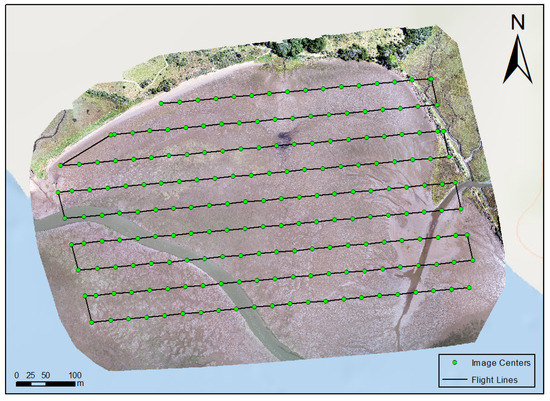
The San Jose State University (SJSU) Geography Program collaborated with various universities for a comprehensive drone mapping project along the West Coast. The initiative aimed to assess eelgrass meadow health and extent, employing UAS technology and fieldwork to gather high-resolution imagery. Students utilized DJI Phantom 4 Pro and Inspire drones equipped with RGB and multispectral capabilities, generating maps for analysis. With sites in Coos Bay, Newport, Friday Harbor, and Bodega Bay, the team collected data, faced weather challenges, conducted marine research, and honed their drone piloting skills. The project, facilitated by partnerships and supported by grants, offered invaluable hands-on experience…
July 16, 2022
[Paper] Ocean Warming Fuels Eelgrass Disease AI-Enabled Climate Surveillance Insights
1 minute read
A study links ocean warming to eelgrass wasting disease across latitudes, spotlighting the risks posed by rising temperatures to coastal ecosystems. By combining satellite temperature data with field surveys spanning 3500 km along North America's Pacific coast, the research found disease prevalence linked to warm anomalies, indicating heightened risks due to climate warming. Utilizing an AI system, the Eelgrass Lesion Image Segmentation Application, enabled rapid and accurate disease quantification, empowering large-scale surveys. The findings emphasize AI's significance in detecting climate-driven marine disease outbreaks and emphasize the increasing vulnerability of eelgrass habitats to warming climates.…
June 03, 2022
[Paper] Traffic Restrictions During 2008 Beijing Olympics Mitigated Urban Heat
1 minute read
The study investigates the influence of traffic restrictions implemented during the 2008 Beijing Olympic Games on urban heat dynamics using satellite thermal remote sensing. By analyzing daily MODIS satellite data on surface temperature and developing statistical models, the research reveals substantial reductions in mean surface temperature by 1.5-2.4 °C and a decrease in heat extent by 820 km2 in Beijing during the period when traffic volume was halved due to road space rationing. These findings suggest a significant correlation between urban traffic and heat intensity, underscoring the importance of managing traffic and fossil fuel use for future urban heat mitigation…
May 02, 2022
![[Post] UCF @Citizen_GIS Collaborates with SJSU @sjsu_urbp for Fieldwork](./posts/images/2022032801.jpg)
[Post] UCF @Citizen_GIS Collaborates with SJSU @sjsu_urbp for Fieldwork
1 minute read
UCF's @Citizen_GIS joined Bodega Bay fieldwork with K12 support. SJSU's @sjsu_urbp presented inspiring talks and lightning sessions, watch on: https://facebook.com/sjsuurbanplanning/videos/544403550277383…
March 28, 2022
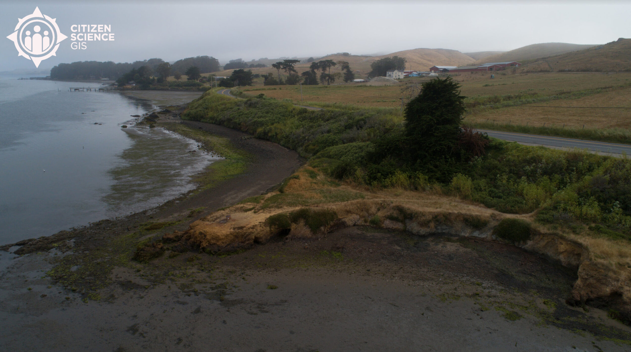
[StoryMap] The UCF Citizen Science GIS team is visiting SJSU and bringing K-12 students from Florida to conduct drone mapping fieldwork in Bodega Bay, CA
1 minute read
Coast to Coast with Astronaut High Explorers…
March 15, 2022
[Paper] Mapping Emotional Attachment in Coastal Restoration Community Perspectives Guide Priorities
1 minute read
The study explores emotional attachment within the Indian River Lagoon, Florida, to inform coastal restoration priorities. Through Geographic Information Systems, aggregate emotional attachment data from stakeholders is mapped. Kernel density estimation (KDE) measures are employed at a broader lagoon scale, while inverse distance weighted (IDW) measures are used at more localized scales. Analyzing these results against participants' reasons for high or low attachment reveals varying spatial patterns of emotional connection as a facet of sense of place. The mapped outcomes aid in identifying and visualizing emotional attachment across different geographic regions, providing insights for prioritizing restoration strategies. This approach connects…
November 30, 2021
[Paper] Remote Sensing Unveils Microbiome Dynamics: Scaling Ecosystem Interactions Profoundly
1 minute read
The article "The Future Is Big-and Small: Remote Sensing Enables Cross-Scale Comparisons of Microbiome Dynamics and Ecological Consequences" explores the integration of remote sensing and microbial omics-based techniques. This interdisciplinary approach offers insights into microbial interactions across different environments. By combining data-rich methods such as remote sensing, machine learning, spatial statistics, and omics data, researchers gain a deeper understanding of microbial communities and their influence on ecosystem structures. The study highlights applications in marine, aquatic, and terrestrial systems, emphasizing the significance of linking biochemical and spatiotemporal environmental data. The aim is to develop a predictive framework for comprehending microbiome interactions…
November 03, 2021
SJSU SAVI GIS Talk: urban and environmental research with using GIS, drones, and data science
1 minute read
Video…
September 24, 2021
Team Completes First Set Of Data Collection For NSF Smithsonian Eelgrass Research
3 minutes read
Original post…
July 04, 2021
![[Post] Dr. Yang joined Department of Urban & Regional Planning at San Jose State University](./posts/images/2021060301.jpg)
[Post] Dr. Yang joined Department of Urban & Regional Planning at San Jose State University
1 minute read
@SJSU_URBP & @SJSUCOSS welcome @BoYangGeo, our new Assistant Prof joining in F'21. With a PhD in Geography from @UC_ArtSci, Dr. Bo Yang specializes in #GIScience, #RemoteSensing, #UAVs, and #CitizenScience. Excited to have their expertise in our team!…
June 03, 2021
The drone education featured at 2021 ESRI Imagery and Remote Sensing Educators Summit
1 minute read
See original post…
March 26, 2021
Advancing GIS Education: Insights from the 'Teaching with Drones' Webinar
2 minutes read
The "Teaching with Drones" web meeting in higher education, hosted by Esri, highlighted the increasing use of UAVs (Unmanned Aerial Vehicles), including drones, for data capture and the rising demand for skills in UAV piloting and data processing in universities. The meeting featured presentations from three experts:…
March 18, 2021
Drones Empowering Communities: Participatory Sciences in Global Perspective
2 minutes read
The MDPI Drones Special Issue on "Drones for Participatory and Community-Based Sciences" is a call for scholarly contributions aimed at exploring the expanding role of low-cost drones in community-based engagement and participatory initiatives. Led by Guest Editors Dr. Timothy L. Hawthorne, Dr. Bo Yang, Dr. Karen Joyce, and Dr. Stephanie R. Rogers, this special issue endeavors to amalgamate diverse research efforts and insights from a global pool of scholars, focusing on the utilization of drones beyond traditional academic and policy-making spheres.…
February 28, 2021
![[Post] Paper on developing a UAV mapping and training program highlighted as the cover story in journal Drones](./posts/images/2021012501.jpg)
[Post] Paper on developing a UAV mapping and training program highlighted as the cover story in journal Drones
1 minute read
Our @citizen_gis recent paper on developing a UAV mapping and training program has been highlighted as the cover story in journal @Drones_MDPI . This is one of the first efforts in using UAV for seagrass research on the Pacific coast @timlhawthorne Paper: https://doi.org/10.3390/drones4040070…
January 25, 2021
[Paper] ST-Cokriging: Assimilating Multi-Scale Remote Sensing for Enhanced Resolution
2 minutes read
The paper introduces a spatio-temporal Cokriging (ST-Cokriging) method, addressing the limitations of individual satellite remote sensing systems that cannot provide Earth surface observations with high spatial and temporal resolutions simultaneously. Due to the inherent trade-off between satellite orbit revisit frequency and sensor spatial resolution, this new method aims to assimilate multi-scale remote sensing data acquired by various systems with diverse temporal sampling frequencies and spatial resolutions.…
December 24, 2020
[Paper] New paper published about drone training program for seagrass along the west coast
1 minute read
See original post…
November 03, 2020
Exploring Seagrass Wasting Disease: Eelgrass Threats and Research Insights
2 minutes read
In the summer of 2020, a team led by Drew Harvell, an ecology and evolutionary biology professor, along with postdoc Lillian Aoki and Ph.D. student Olivia Graham, embarked on a research expedition to the San Juan Islands in Washington state to investigate the causes behind seagrass wasting disease. The team shared their marine adventures and findings on Twitter through accounts such as @DrewHarvell , @lillian_aoki , and @o_jgraham .…
October 19, 2020
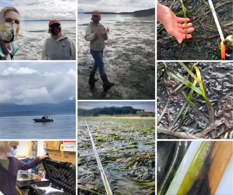
Summer NSF Pacific Coast Drone Mapping Completed Safely During COVID-19
4 minutes read
Original post…
September 16, 2020
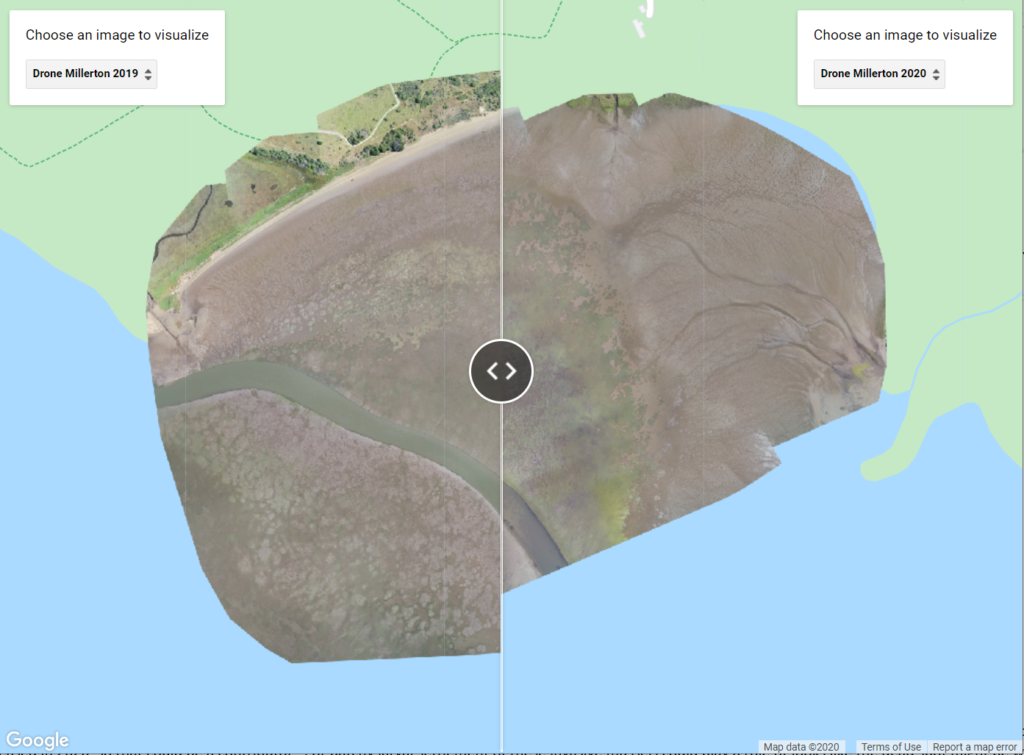
NSF Drone Mapping Finds A Change Of Eelgrass Bed In Spatial Extent And Patchiness
3 minutes read
Original post…
July 20, 2020
Citizen Science GIS Uses Remote Drone Mapping In Response To COVID-19
2 minutes read
Original post…
July 07, 2020
New Teacher Funding For Drones, GIS And Fieldwork From Our NSF Grant
3 minutes read
Original post…
April 22, 2020
[Paper] Spatio-Temporal Fusion Enhances Crime Prediction Using Multi-Source Data
2 minutes read
The study proposes a novel method for crime prediction by merging historical crime data with transitional zones identified from VIIRS nightlight imagery. Crime prediction plays a crucial role in optimizing police resource allocation for crime prevention. While existing approaches focus on historical crime or environmental variables linked to criminal patterns, this research introduces a novel spatio-temporal Cokriging algorithm blending multi-source data for more accurate crime forecasting.…
March 13, 2020

Our Maps, Apps & Drones Tour And GeoBus Celebrate GIS Day At UCF
3 minutes read
Original post…
November 18, 2019
Capturing the Beauty of Belize from Above with Smithsonian MarineGEO
1 minute read
See original post…
November 08, 2019
Kirsten Bouck And Morgan McDonald Win Student Presentation Competition
1 minute read
Original post…
September 12, 2019
The Golden Rule, DroneCat And GeoBus At Central Florida GIS Workshop
1 minute read
Original post…
September 12, 2019

Citizen Science GIS Completes Drone Work In Alaska The Last Frontier
4 minutes read
Original post…
August 07, 2019
[Paper] Enhancing Coastal Management UAV vs Satellite for Detailed Mapping
2 minutes read
The study investigates the efficacy of utilizing Unmanned Aerial Vehicle (UAV) multispectral mapping techniques in coastal management compared to conventional remote sensing methods like satellite imagery. Conducted in the Indian River Lagoon along Florida's central Atlantic coast, the research aims to quantitatively illustrate the advancements and benefits of high-resolution UAV imaging for precise coastal land cover assessment.…
July 27, 2019
UCF Drone Team Finishes The Mapping In Southern California With SDSU And Smithsonian
3 minutes read
Original post…
July 25, 2019
UCF Drone Team Finishes Eelgrass Research Alongside UC Davis
4 minutes read
Original post…
July 16, 2019
UCF Drone Team Finishes Eelgrass Mapping With Team From Oregon State And Cornell
2 minutes read
Original post…
July 01, 2019
UCF Drone Team Finishes Eelgrass Mapping With Team From UW And Cornell
3 minutes read
Original post…
June 12, 2019
![[Paper] Geostatistical Approach for Enhanced Land Use Mapping and Prediction](./posts/images/Picture78.jpg)
[Paper] Geostatistical Approach for Enhanced Land Use Mapping and Prediction
2 minutes read
The paper titled "Sharpening Land Use Maps and Predicting Land Use Change Trends Using High-Resolution Airborne Images: A Geostatistical Approach" addresses the critical need for detailed and regularly updated land use/land cover (LULC) data, essential for comprehensive Earth surface characterization, predicting land use changes, and evaluating development plans' impacts.…
June 01, 2019

Researchers At Univ. Of Central Florida Are Going To Use Geo-Statistical Approach To Blend UAV Imagery With Satellite Data For Monitoring Seagrass Along West Coast.
2 minutes read
Original post…
April 09, 2019

Dr. Yang Presents Multi-Spectral UAV Mapping At UCF Research Week Event
1 minute read
Original post…
April 05, 2019

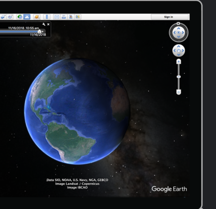
2019-03-29-How To Create Region Of Interest (ROI) In Google Earth Desktop Using KML File
1 minute read
Google Earth on desktop is free for users with advanced feature needs. It's a really useful resource allowing users to import and export Geographic Information System (GIS) data, and go back in time with historical imagery. Available for free for download on PC, Mac, or Linux. We've created this quick guide for our friends new to Google Earth. Happy mapping!…
March 29, 2019
2019-03-29-How To Create Region Of Interest ROI In Google Earth Desktop Using KML File
1 minute read
Original post…
March 29, 2019
Multi-Spectral Drone Mapping Fieldwork In Indian River Lagoon
3 minutes read
Original post…
March 11, 2019
UCF GIS Academy Empowers Educators for Spatial Teaching Integration Success
2 minutes read
Original post…
February 05, 2019